 Douglas
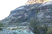
Creek is a lovely place, one of the few year-round creeks in the Columbia
Basin, draining thousands of acres of land owned by the public and managed
by the Bureau of Land Management. The creek and its tributary, Duffy Creek,
flow from the dry sage-steppe uplands east of Badger Mountain and the
farmland of the Waterville plateau, running through a hidden oasis of
beaver ponds, waterslides and pools in a deep basalt canyon that drains
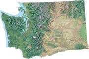
to wide-open Moses Coulee. The area is located east of Wenatchee, south
of Waterville, and north of Quincy, Washington.
Douglas
Creek is a lovely place, one of the few year-round creeks in the Columbia
Basin, draining thousands of acres of land owned by the public and managed
by the Bureau of Land Management. The creek and its tributary, Duffy Creek,
flow from the dry sage-steppe uplands east of Badger Mountain and the
farmland of the Waterville plateau, running through a hidden oasis of
beaver ponds, waterslides and pools in a deep basalt canyon that drains
to wide-open Moses Coulee. The area is located east of Wenatchee, south
of Waterville, and north of Quincy, Washington.
 Douglas
Creek is a familiar place to local residents as a hideaway for camping,
hunting, and hiking, with fishing for rainbow trout on the lower stretches.
A single road provides primary access to the area, but this road is closed
on the Moses Coulee end due to a few feet of creek over the road. Water
also covers the road in the middle of the area when beaver ponds fill
up after rainstorms, at times restricting vehicles to a relatively compact
area having free campsite pullouts.
Douglas
Creek is a familiar place to local residents as a hideaway for camping,
hunting, and hiking, with fishing for rainbow trout on the lower stretches.
A single road provides primary access to the area, but this road is closed
on the Moses Coulee end due to a few feet of creek over the road. Water
also covers the road in the middle of the area when beaver ponds fill
up after rainstorms, at times restricting vehicles to a relatively compact
area having free campsite pullouts.
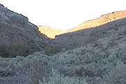
Despite the limited access, there's plenty of room to hike around and explore the unique landscape, and it's lonesome enough to sneak a shower under a waterfall to cool off on a hot day. Hiking up the ridge to the west of the creek on the Palisades end leads up to spectacular views of Moses Coulee, while trails lead off from the Waterville end up a remote portion of the creek and ridge roaming with splendid wildflower displays from April to June.
 A
short scramble up the slope and along the ridgetop leads a hiker past
some of the five varieties of desert
buckwheat found in the area. Common in the shrub-steppe, desert buckwheats
bloom from early spring into late summer depending on the variety, with
yellow or white flowers that turn pink or rose as they dry. Desert buckwheats
provide a timely nectar source for shrub-steppe bees, agriculturally beneficial
wasps, and butterflies while
their seeds are a favorite food for various birds and rodents.
A
short scramble up the slope and along the ridgetop leads a hiker past
some of the five varieties of desert
buckwheat found in the area. Common in the shrub-steppe, desert buckwheats
bloom from early spring into late summer depending on the variety, with
yellow or white flowers that turn pink or rose as they dry. Desert buckwheats
provide a timely nectar source for shrub-steppe bees, agriculturally beneficial
wasps, and butterflies while
their seeds are a favorite food for various birds and rodents.
The area provides living space for a wide variety of birds and mammals common to Columbia Basin shrub-steppe and streamside habitats. Mammals and reptiles in the area include mule deer, coyote, porcupine, various bats, gopher snake and western rattlesnake.
Washington Audubon Society has designated Douglas Creek an Important Bird Area in Eastern Washington (p 32 of 58 Acrobat). Neotropical migrant birds use the area during migration and several species such as the black-headed grosbeak, lazuli bunting, Bullock's oriole, western meadowlark, and vesper sparrow take up residency for summer breeding. House finch, black-billed magpie, black-capped chickadee, northern flicker, and red-tailed hawk are also common.
Around the creek, look for serviceberry (Amelancier alnifolia), squaw currant (Ribes cereum), mock orange (Philadelphus lewisii) and purple sage (Salvia dorrii). Riparian willows may be host to the Viceroy, a large, orange Monarch butterfly look-alike that used to be relatively common but is now a rarity in the mid-Columbia region.
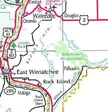
Directions from the north:
Take State Highway 2 about eight miles east of Waterville and follow Road
H southwest down Slack Canyon into Douglas Creek creek canyon.
Directions from the south:
Follow Highway 28 and turn onto Palisades Road and follow for about 10
miles. When the road turns east away from Douglas Creek, look for a left
turn at the graveled Wagon Road, take it and drive 1.5 miles. Park at
one of the pullouts before the creek.
For more information about the Douglas Creek - Duffy Creek area, a variety of excellent sites are listed at the left of the page.